GPS Coordinates Format: Decimal Degrees, DMS and DDM Explained
GPS coordinates format explained: decimal degrees, degrees minutes seconds (DMS) and decimal minutes (DDM), with examples, conversions and decimal places.
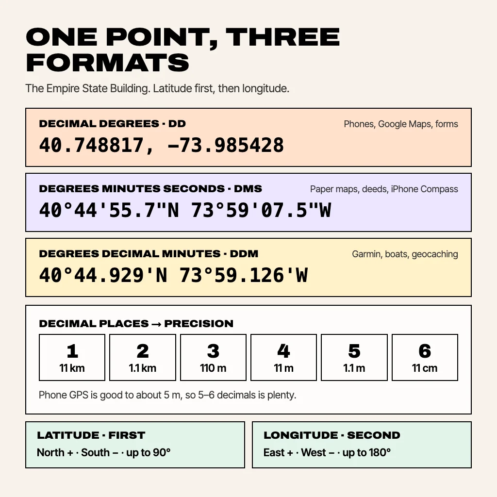
GPS coordinates are written as latitude first, then longitude, in one of three formats: decimal degrees (40.748817, -73.985428), degrees minutes seconds (40°44'55.7"N 73°59'07.5"W) or degrees and decimal minutes (40°44.929'N 73°59.126'W). All three describe the same spot, the Empire State Building, in different notation. Decimal degrees is the format phones, Google Maps and spreadsheets use. DMS is common on paper maps and in surveying, and DDM is the default on many marine and handheld GPS units. Here's how to read each one, convert between them, and avoid the mistakes that send a pin to the wrong country.
How to read GPS coordinates
A coordinate is two angles measured from the centre of the Earth:
- Latitude is how far north or south of the equator you are, from 0° at the equator to 90° at each pole. It always comes first.
- Longitude is how far east or west of the prime meridian at Greenwich you are, from 0° to 180° each way. It always comes second.
North and east are positive, south and west are negative. So New York (north and west) has a positive latitude and a negative longitude, and Sydney (south and east) has a negative latitude and a positive longitude. The GPS system and almost every map app use the same reference model of the Earth, called WGS 84, so a coordinate copied from your phone lands in the same place in any modern map.
Decimal degrees (DD)
Format: 40.748817, -73.985428
Each angle is a single number with a decimal fraction, and the sign carries the direction. This is what Google Maps, Apple Maps, phone GPS apps, databases and most web forms use, because it's one number per axis and easy to paste. When someone asks for "GPS coordinates" without saying which format, send decimal degrees.
Degrees, minutes, seconds (DMS)
Format: 40°44'55.7"N 73°59'07.5"W
Each degree is split into 60 minutes ('), and each minute into 60 seconds ("). The direction is a letter (N, S, E or W) rather than a minus sign. You'll see DMS on topographic and nautical charts, in property deeds and survey documents, and in the iPhone Compass app, which shows your position this way at the bottom of the screen.
Degrees and decimal minutes (DDM)
Format: 40°44.929'N 73°59.126'W
Whole degrees, then minutes with a decimal fraction, and no seconds. Garmin handhelds and many boat chartplotters default to this (Garmin writes it as hddd°mm.mmm'), and geocaching listings use it too. If a sailor or geocacher reads you a position, it's probably DDM.
How many decimal places do GPS coordinates need?
Each decimal place in decimal degrees makes the position about ten times more precise. For latitude anywhere, and for longitude at the equator:
| Decimal places | Example | Precision | Good for |
|---|---|---|---|
| 1 | 40.7 | ~11 km | A city |
| 2 | 40.75 | ~1.1 km | A neighbourhood |
| 3 | 40.749 | ~110 m | A large building or field |
| 4 | 40.7488 | ~11 m | A house or a car park |
| 5 | 40.74882 | ~1.1 m | A front door or a tree |
| 6 | 40.748817 | ~11 cm | Survey markers, the limit of useful phone data |
Longitude degrees shrink as you move away from the equator, so at New York's latitude a longitude decimal is about three-quarters of these distances. Anything past six decimals is false precision: a phone's GPS fix is typically good to about 5 metres outdoors, so the seventh and eighth digits are noise.
How to convert DMS to decimal degrees
Decimal degrees = degrees + minutes ÷ 60 + seconds ÷ 3600. Then add a minus sign for S or W.
Example, Sydney Opera House at 33°51'24.5"S 151°12'55.1"E:
- Latitude: 33 + 51 ÷ 60 + 24.5 ÷ 3600 = 33.856806. It's south, so -33.856806.
- Longitude: 151 + 12 ÷ 60 + 55.1 ÷ 3600 = 151.215306. It's east, so 151.215306.
In Excel or Google Sheets, with degrees, minutes and seconds in A2, B2 and C2, use =A2+B2/60+C2/3600 and multiply by -1 for south or west.
How to convert decimal degrees to DMS
- The whole number is the degrees. For 40.748817, that's 40°.
- Multiply the decimal part by 60: 0.748817 × 60 = 44.92902. The whole number is the minutes, 44'.
- Multiply the new decimal part by 60: 0.92902 × 60 = 55.74. That's the seconds, 55.7".
- Swap the sign for a letter: positive latitude is N, negative is S; positive longitude is E, negative is W.
Result: 40°44'55.7"N. For DDM, stop after step 2 and keep the decimal minutes: 40°44.929'N.
Common GPS coordinate mistakes
- Swapping the order. Longitude first is how GeoJSON and some developer tools store points, but people and map apps expect latitude first. If your pin is in Antarctica or the ocean, try swapping.
- Dropping the minus sign.
-33.8568, 151.2153is Sydney; without the minus it's open Pacific Ocean east of Japan. - Mixing formats.
40.44.55is not a valid coordinate. Either write40°44'55"or convert to40.748611. - Commas as decimal points. In many European locales
40,7488is normal, but map search boxes read the comma as the separator between latitude and longitude. Use full stops. - Treating minutes as decimals. 40°30' is 40.5°, not 40.30°, because minutes are sixtieths.
Other coordinate formats you might meet
- UTM splits the world into 60 zones and gives positions in metres east and north within a zone. Hikers, foresters and search-and-rescue teams like it because grid squares on a map are a fixed size.
- MGRS is the military grid built on UTM, written as a zone, a square and digits.
- Plus codes are Google's short codes for places without street addresses. Google Maps shows one on every dropped pin, and you can search them like an address.
Get clean coordinates on Android
GPS Coordinates Map shows your position in decimal degrees as soon as it opens and copies a clean latitude, longitude pair in one tap, ready to paste into a form or a chat. Drop pins, search an address to get its coordinates, or measure the distance between two points. GPS Pro exports saved places to CSV with separate latitude and longitude columns, which open straight in Excel or Google Sheets. To pull the same numbers out of Google Maps, see how to find coordinates on Google Maps.
Common questions
What is the correct format for GPS coordinates?
Latitude first, then longitude, separated by a comma. In decimal degrees that looks like 40.748817, -73.985428, with minus signs for south and west.
What format does Google Maps use for coordinates?
Google Maps shows decimal degrees, and its search box also accepts DMS and degrees with decimal minutes.
How many digits should GPS coordinates have?
Five decimal places is about 1 metre and is enough for almost anything. Six (about 10 cm) is the most a phone can usefully give.
Is latitude or longitude first?
Latitude (north–south) comes first and longitude (east–west) second. GeoJSON and a few developer formats are the exception.
What is the difference between DMS and decimal degrees?
DMS splits each degree into 60 minutes and 60 seconds and uses N/S/E/W letters. Decimal degrees writes the same angle as one decimal number with a plus or minus sign.
From the studio
Previous Article
How to Find Coordinates on Google Maps (Android, iPhone and Computer)
Next Article
How to Use Your Phone as a Speedometer (Android and iPhone)